The problem with the internet it is just too damn easy. One little click and you have made that commitment. Or maybe that is not a problem, maybe that is actually a blessing and in this case I definitely think it was a blessing. So I clicked on "purchase ticket" and turned to my wife with whom I had been discussing this possibility for a couple of years and said, "Guess I'm going to go to the John Muir Trail". I was leaving in just about one week!
There are two major obstacles to hiking the JMT besides the 210 miles and 48,000 miles of ascent. One, is getting there and two is obtaining a permit. Starting in Yosemite and finishing at Mt. Whitney means the JMT is logistically difficult to get to. If I had to do it again, I'd probably looking at flying either into Fresno or directly to Mammoth Lakes. As it was, I flew into Reno and arrived at midnight and had to wait until 1:00 pm the next day to take the Eastern Sierra Transit Bus to Lee Vining. I was going to stay at the airport but while awaiting to pick up my backpack, I found on my i-phone a motel 6 about two miles from the airport for only $40. That seemed a lot better place to spend 13 hours and plus it gave me a chance to practice carrying my 30 lb pack.
The next day the ESTA bus dropped me off at Lee Vining but that still put me 20 miles from Tuolomne Meadows where I HOPED to obtain a permit at the Wilderness Office. The line for a permit begins forming early in the morning like at 5 am and so if I stayed in Lee Vining I could catch a 7:30 am shuttle but that would put me pretty far back in line so as per my original plan, I pre-made a sign "Tuolomne Meadows" and hitched.
This may seem dangerous but its what most people do to get around Yosemite and is very common. Everyone going down that road is headed over Tioga Pass to Yosemite and I have a big backpack on so it's pretty obvious that my intentions are good. I waited about 20 minutes when a father and son who had been hiking for six days gave me a lift. They gave me a lot of good advice which was very much appreciated.
I was happy to get to Tuolomne Meadows around 6 pm so I got a bit to eat from the store and set up my camp at the backpackers camp. I also got to drink several beers from the store which I enjoyed because I wasn't sure when I'd get to have those beers again.
I actually slept pretty well that first night and woke up and got to the permit office about 6:30 am which was about a 1/2 mile away from the camp. When I got there, I was tenth in line. Now the permit process is very complicated but as long as you are flexible, the rangers will work with you. In my case, the ranger asked if I wanted to start today to which I of course most certainly did and she was able to get me a permit from Sunrise Trailhead which was only about 10 miles from Happy Isles (which is the official starting point of the JMT). Works great for me. So after learning how to poop in the woods and getting my bear cannister along with other instructions from the rangers, I was on the shuttle and at my trailhead at 10:40 am and ready to start my journey!
 |
| The line outside the Wilderness Office. |
 |
| Important information. |
 |
| The Permit I Had Worried So Much About |
 |
| My approximate 30 lb pack with bear cannister. |
DAY ONE - 22 plus miles - Start 10:40 am, Finish 7 pm - Start at Sunrise Trailhead, Finish 6 to 7 miles beyond Tuolumne Meadows.
The trailhead from Sunrise is a pretty good uphill climb for about 4 1/2 miles until it joins the JMT. By the time I reached the JMT I had begun to work up a sweat and two of my water bottles were nearly empty. I thought I would already have to try to find some water to refill and right about that time I came to the point where the trail joined the JMT and lo and behold there was actually a spigot and restrooms! That was
convenient. So I was able to refill my bottles and knew I would be set for the next ten or so miles until I reached Tuolomne Meadows. The was a beautiful hike/run and the trail was pretty level to rolling for most of it and it allowed me to really make up time after the first 4 1/2 miles of mostly ascent.
 |
| Ready to roll - yes I know those are some big sun glass but better to look dorky than suffer from the sun. |
As I made my way past one of the prettier alpine lakes, I noticed a hotel towel (the kind with a stripe down the middle of it) laid out on a log near one of the lakes apparently left there by someone. I realized then that I had forgotten to pack a towel and so I picked it up. That turned out to be a very wise decision because that towel could be used to dry my feet when I cleaned them, as a way to shield my head and neck from the sun. As a mat to put my feet on when I made camp in the evening and a variety of other uses.
 |
| This was an incredible view from this spot. Have my towel to keep from sunburn on the neck. |
Toward the end of this section I had begun to get pretty tired since most of this hike was during the heat of the day. As is usual, the later it got in the afternoon, the less running I did as I felt my energy begin to wane and felt the need for more food. Speaking of food, I had not ate anything since the oatmeal I had for breakfast so I was really looking forward to an early dinner from the grill at Tuolomne. I made it to the grill around 4:00 and immediately ordered a burger basket and a big cookie and got a big beer from the store. I sat down at the picnic tables and it was delicious.
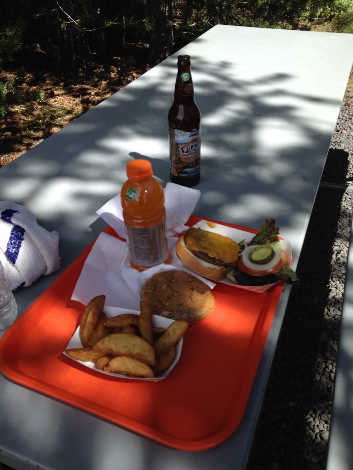 |
| Great meal at Tuolomne Meadows |
I savored the beer and took off my socks and shoes and cleaned my feet. I really needed gaiters and that would be a big mistakes as sand and dirt would really irritate my feet throughout this journey having just worn running shoes. I did bring about a dozen pairs of socks and essentially could wear a new pair every day and this helped.
So with a very full stomach, I decided that I would hike easily for an additional two hours. The hike from Tuolomne is very easy and flat and so I think I made it five or six miles. It was a nice hike as I had cell reception and was able to talk to my wife for a while. I found a very nice camping spot that evening and set things up. I had carried two beers with me out of Tuolomne and so I drank those contentedly and then crawled into my tent for what would be a pretty good nights sleep.
 |
| Great campsite on the first night. |
DAY TWO - 30 Miles - Start - 6:39 am - Finish - 6:09 pm - From just 6 miles south of Tuolomne to Red's Meadow Resort
I woke and had lots of oatmeal but skipped my coffee because I wanted to hit the trail pretty early. Shouldn't have rushed so much but I really hoped to make it to Red's Meadow for another hot meal and a shower would be great too.
The hike continued through the beautiful valley until it started to rise over Donahue pass. Maybe it was just because I was still fresh but I think the climb up Donahue Pass was one of the easier and shorter ones. It certainly was a lot shorter than Muir Pass later on. I was up and beyond it pretty early. I think it was well before 10 am when I left the Yosemite National Park. It was as all of this trail is, incredibly beautiful.
 |
| View near Donahue Pass |
 |
| At the top of the pass leaving Yosemite and Crossing into Ansel Adams Wilderness |
After Donahue Pass, you come to Thousand Island Lake and the trail for the rest of the day would go up a pass, down to a lake, up to a pass, down to a lake. Again and again. Each lake unique and beautiful. This day would be warm as well with no clouds so I definitely needed my towel.
 |
| View near Thousand Island Lake (I think) |
For most of the day it was just stunning beauty as you go up over a little pass and down and around an alpine lake but but 3 or 4 pm I was definitely tired of the up and down and began wondering if I could even make it to Red's Meadow. It was right around that time that there was a long downhill section all the way to Devil's Postpile and into Red's Meadow.
 |
| Maybe my best panoramic picture of the entire trip. |
About two or three miles from Red's I heard a car horn and knew I must be close but I was really drained and it seemed to take forever.
 |
| Red's Meadow At Last |
Red's Meadow was okay. The cafe had a really good burger. I ordered the double bacon cheeseburger and finished it off along with potato salad and a beer. That was of course after a long hot shower which if I remember correctly cost $7.
The bad part about Red's is that they were not really welcoming as Vermillion would be the next day and you had to hike an additional half mile to the campground which you had to pay for (although I managed to avoid that). If I had not been so wore out, I think I might have been better off hiking a couple of miles further down the trail and setting up camp there and in hindsight, I probably should of done that even if I were fatigued because the little backpacker's camp was kind of crowded.
There was good cell reception there and so I was able to talk a lot with my wife. It was pretty low moment for me only my second full day out. At only 57 miles, I seemed so far from the end and I was really exhausted from a long hard day. I crawled into my tent for a very restless night of sleep.
DAY THREE - Red's Meadow to Vermillion Ranch Resort - 33 Miles - Start 7:09 am and Finish 6:30 pm.
I woke up determined not to rush to get on the trail. But even with a relaxed striking of camp and eating oatmeal and then savoring some instant coffee, I was still ready to go pretty early. Even though I never really slept well, the mere fact of staying in the tent for ten hours must have allowed my body to rest quite a bit because once I started my hike, my attitude was a complete 180!
I talked to Suzanne on the phone for the first 30 minutes or so as I hiked and I messaged her this picture:
 |
| This view that I texted to my wife along with the conversation got my spirits up again. |
I was really enjoying it again and couldn't believe what a difference a night made. After talking with her, I picked up the pace and began really ticking off some miles. This was much better terrain than the previous day and a lot of it was very runnable. Then came quite a bit of downhill as I ran along Purple Lake which was so beautiful. Then up again and own to another much larger lake that I cannot remember the name of. I had lunch there and it was the best lunch spot I had of the entire trip.
 |
| Views from Day Three |
 |
| Purple Lake was so much more beautiful than this picture can show. |
 |
| A great lunch spot. |
After lunch I rally began to pick up the speed and there was a huge downhill that was so beautiful with a huge flowing waterfall along side and a really neat walking bridge that crossed the waterfall.
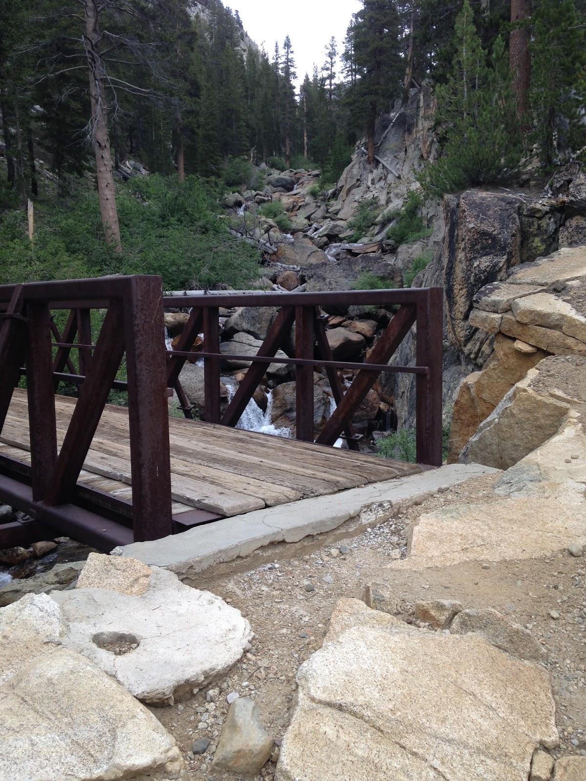 |
| It was impossible to get a good picture that could capture this waterfall and bridge. |
 |
| View on the way up to a very difficult climb. |
I started climbing up the pass as it went up and up and the climbing was really getting tough. It was toward the end of the day and I had already done twenty miles so that made it even worse. But then to make matters worse, once you get to the top of the pass, you take the alternate trail to VVR which means you have to go up more to an additional pass! I'm not sure how many more feet of climbing the second pass was but it seemed like it must have been a thousand feet of additional climb.
Making matters worse, the descent from the pass had terrible footing and was very rocky so I could not really run and just struggled not to trip on the jagged rocks. As always, the trail began to go back into the treeline and thus I was able to run some. After what seemed like an eternity, at about 5:15, I came to a group of campers and asked how far to VVR - their response was 4 miles! I could not believe I had four more miles to go. So I just did the only thing I could do and I just bore down and ran hard the last four miles to VVR. It was a little confusing the last mile on how to get to the resort and I even had to call and ask for directions. For those wanting to know - go to the trailhead and then follow orange ribbons to VVR.

Just as I had read online, when I walked into VVR, the really nice lady there told me the first beer is on the house for thru hikers. Once again I was exhausted from a really long day and so grateful for this. I had been dreaming about having that beer for sometime and now it was a reality. It was awesome. I took another shower and ordered the special which for that night was fried chicken and mashed potatoes. By far this was the best meal of my entire trip! I made quite a new friends while I ate and drank some beer.
A really nice couple offered me an extra bed in their cabin but I told them I was okay in my tent. They were in disbelief that I had done Reds to VVR in a single day as it took them three hard days. I met a nice couple from Colorado that were also thru hiking and several others people with whom I had beer around the campfire. The younger 'kids' were playing music and it was just a really great place. I worried that it might be too loud to sleep but sure enough by ten o'clock it seemed as if the entire resort had fallen into a deep slumber.
DAY FOUR - 25 miles - Start 9:40, Finish 7 pm - VVR to start of King's Canyon National Park - Just past the bridge over a beautiful rushing stream.
So the beginning of this day was the moment I decided to cut the hike a little short and not go to the very end at Whitney Mountain. I hated that I would not finish but at the same time, I knew that could without too much difficulty. My greatest concern was that I would be out of cell contact with my family for four days and then would have to wait another three days before I could get the bus back to the Reno Airport. The other option was to go to Bishop, be out of cell contact for two days and then be back home the following day. So I chose the latter because it just seemed more reasonable and less stress for me and my family.
In hindsight now, I really don't regret the decision because I feel like I really got the heart of the trail and this just gives me reason to go back and do the entire trail next time. I only had 60 miles left that I did not get to see.
I had a late start because I had to wait for the shuttle to take us around Thomas Edison Lake and then I had to call and make arrangements for hotel and flight and talk one last time with my wife. So I hit the trail at 9:40 and the hiking was pretty good. I felt really rested from having ate both a hot full dinner and a hot and full breakfast at the VVR grill. The pass we went over that day did get a little scary as a storm moved in.
 |
| Just before the storm moved in. |
It was scary enough that I retreated back down from the pass and set up my tent at a basin and had lunch inside the tent and rested for 30 minutes or so as I waited for the storm to pass. There was a little hail and some thunder but it blew over pretty quick. I was able to quickly pack up and continue moving.
As I got down the other side, the trail strangely became for the first time very empty. There were very few people. At times I wondered if I was still on the right trail because up until that time I had seen people every half mile or mile. No I had gone several miles without seeing a soul. As the trail reached the bottom near Muir Trail Ranch (which I had totally forgotten about and didn't even see the turn) you came through a valley with huge sequoias and it was quite beautiful. Finally I passed someone at about 6 in the evening going Northbound and he had not seen anyone either and also wondered if he were on the right trail. It was reassuring for both of us.
 |
| Beautiful trees near Muir Trail Ranch. Trees look much larger in person. |
I continued on looking for a good campsite and there was none. I told myself that at 7 pm, I'm going to plop down and camp where ever I am at because I was exhausted. Luckily it just so happened that at seven o'clock I crossed a bridge into King's Canyon National Park and a perfect campsite next to a roaring river that others had already set up near. That was nice.

 |
| This river was really flowing. I think that might have been one of the longer stretch without water. |
I ate a filling though not very tasty rice and chicken meal and into my tent I went for a good ten hours of rest. It was a beautiful campsite.
 |
| One of the better campsites along the river. |
 |
| Calories - nothing more, nothing less. Just getting calories. |
DAY 5 - 27 Miles - Start 7:20, Finish 6 pm - King's Canyon NP Start to Bishop Pass Trail Exit -
 |
| Nothing like seeing the sun come up in the mountains. |
 |
| At the basin beneath Muir Pass - notice the clouds thickening. |
But it was not plenty of time because the storm moved in faster than expected and Muir Pass was FAR LONGER than I ever expected. This was probably the time that I was most afraid during my entire trip. I did not want to get caught on a pass during a lightening storm but felt like it was too far too go back. I thought it was probably easier to try to go ahead over the pass and get down quick the other side.
 |
| Shelter on top of Muir Pass - the clouds were pretty dark but the storms stayed away on nearby mountains. |
 |
| The clouds were very pretty as they hung low after the storm. |


Exhausted I had a minimal late lunch and then pushed on. Mostly down hill now, I kept going until about 5:00 when I reached the Bishop Pass Trail. I hiked a few more miles up the Bishop Pass Trail until I found a camp spot. It was bitter sweet leaving the JMT but I know I will be back.
I laid in my tent and looked at the pictures I had taken on my phone and was happy that I would be finally able to call and talk to my family and in two days I'd be home! I worried that they must be really worried about me and was said that I had no signal on Muir Pass. As I laid there, I also could tell that I'd lost quite a bit of weight in the past week. It was really amazing that my stomach had shrunk so quickly despite my best efforts to really put in tons of calories.
That was a very restless night, really had trouble sleeping. Next time I need to bring one of those little blow up air mattress or sleeping pads.
DAY SIX - 12 plus miles - Start 6:30 , Finish 11:00 am
 |
| Some pictures from the final morning. Mornings were always the best. Rested and beautiful as the sun came up. |


Bishop Pass wasn't too bad to get up and it was very beautiful. But it was very steep and rocky coming down toward Bishop. But it wasn't long before I was at the trailhead. I only had to hitch for about 20 minutes before getting a ride into town which is about 20 miles from the TH.
I was so anxious to call my family and let them know I was okay. I had not talked to them in two and half days. When I finally got a cell signal I called and talked to my daughter Madeline and told her I know she was worried about me but I was okay. She simply responded that no, she wasn't worried, why should she be worried. Guess I could have continued on the last couple of days after all. Will have to remember that next time.
I rode down from 9000 feet (13000 from top of pass) to 4000 feet and for the first time in a week or more, I really felt the summer heat. It must of been near 100 degrees in Bishop. After I was dropped off at the edge of town, I walked through town and passed the post office and so that was a good time to send back my bear cannister. Got my room and some really good food and was ready to go home.
 |
| View of the Eastern Front Range of the Sierra Nevada Mountains from my bus riding back to Reno. |
It was an extraordinary trip and my first really big thru hike. I really learned a lot from it and feel like I have many years of thru hike adventures ahead of me. I'd like to do at least one a year to take a break from and train for ultra runs. It really is a different type of adventure from the ultra run.
Not sure what to do next summer. I may come back to do the JMT again and make sure I finish. I feel very comfortable there now. I may try to do the entire Colorado Trail or a different portion of the Pacific Crest Trail. Of course there is always others like part of the Continental Divide Trail further north in Idaho would be fun too. What's great is there is far more trails than I could ever do in a lifetime and I look forward to exploring as many as possible.

So great that you're back to running! How are you doing now since your last post? I got a PRP injection for my hamstring on November 9th and I'm still recovering. From time to time I read your blog to give me hope! It was more painful than I thought and the recovery is like I just injured my hamstring again. But I have faith that it will work! Take care!
ReplyDeleteSorry for such a belated response. I'm doing well. I'm nothing like the runner I once was as it is no longer so effortless but the important thing is that I can run and sometimes like yesterday, I can run a marathon without pain. Those are the good days. I hope your recovery is well and that you are back on the trails.
ReplyDelete